|
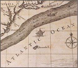
A Chart of the Gulf Stream, 1786. |
This afternoon we took up several branches of gulf weed; but one of these branches had something peculiar in it…a small yellow berry filled with nothing but wind; besides which it bore a fruit of the animal kind, very surprising to see. It was a small shell-fish like a heart.
—Benjamin Franklin,
Journal of a Voyage, 1726
|
|
|

|
|
Never one to waste an opportunity or to pass the time unoccupied, Franklin used his multiple transatlantic journeys—which lasted weeks in each direction—to observe and study the natural phenomena around him. Franklin carefully recorded his observations, keeping journals filled with details documenting the origins of storms, the formation of lightning, and the effects of oil on water. His fascination with maritime weather led him to include meteorological information in his Poor Richard’s Almanack, helping both travelers and colonial farmers prepare for shifting weather patterns.
Franklin also studied the transatlantic path of the Gulf Stream, charting its route with his cousin Timothy Folger, a Nantucket whaling captain. Their surprisingly accurate map has been widely used by seamen of many nations, reducing the lengthy ocean crossing and spurring interest in the mysteries of the Atlantic. |